Product · Driver advisory system (DAS) · Android
HISIMDAS
HISIMDAS is a driver advisory system that gives train drivers real-time energy-efficient (eco) driving advice throughout the trip. It works together with the Hi-SimTrain server: the server computes the driving profile and the app shows it to the driver on a phone or tablet in the cab.
- What
- A driver advisory system (DAS) app that gives train drivers real-time eco-driving advice.
- For whom
- Train drivers. For organisational use; the railway operator provides the accounts.
- How
- Hi-SimTrain computes the profile; the app estimates position from the device’s sensors and shows the advice in the cab.
- Platform
- Android 8.0+ phones and tablets; Turkish and English UI
Example simulation
What the driver sees in the cab
Hi-SimTrain computes the profile; the app estimates position from the device’s sensors and shows the advice in the cab.

What the driver sees in the cab: speed, limit, advice and next station
HISIMDAS Screens and views
Screens in the cab

Sign in server choice (DEV / PROD), username and password 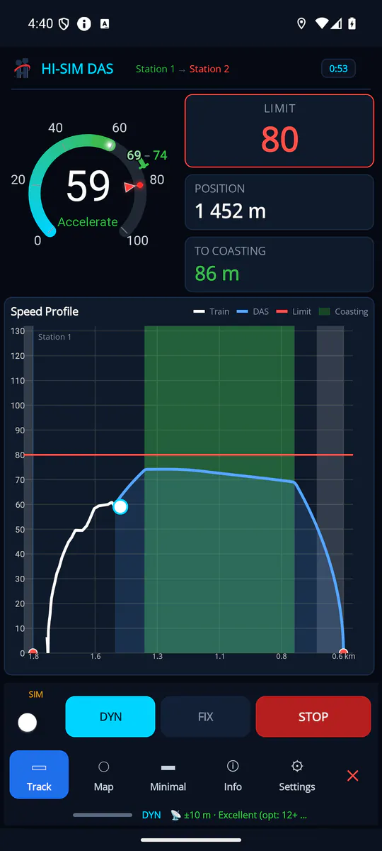
Track · ACCELERATE speed profile, limit and the green coasting band 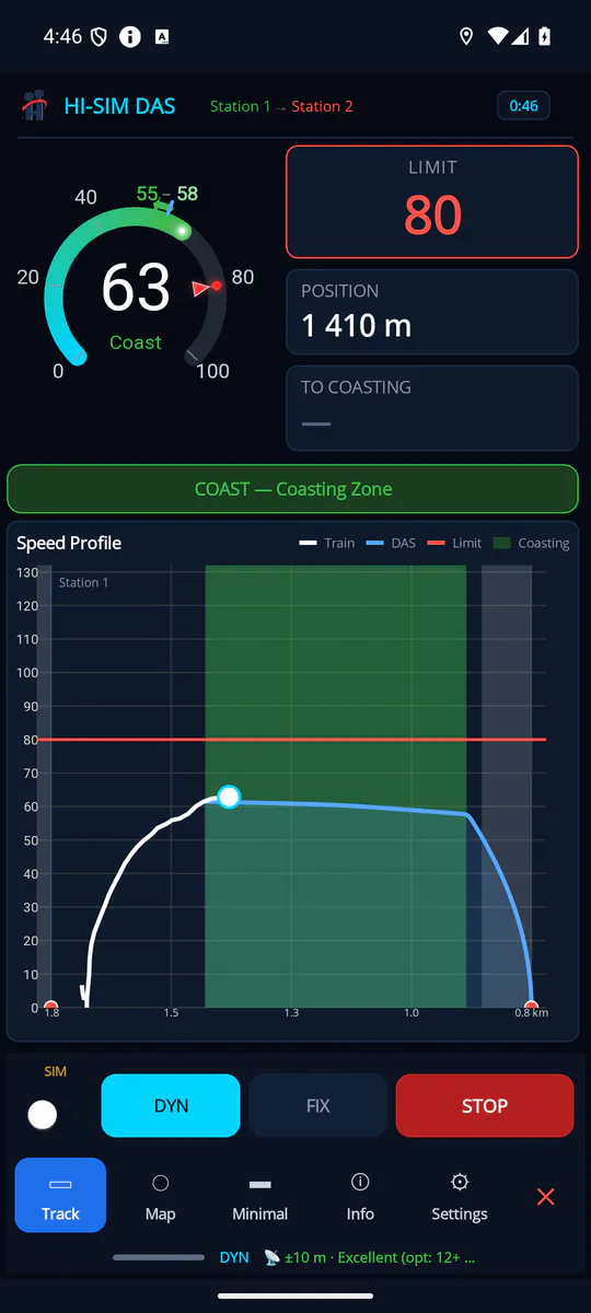
Track · COAST the coasting-zone banner 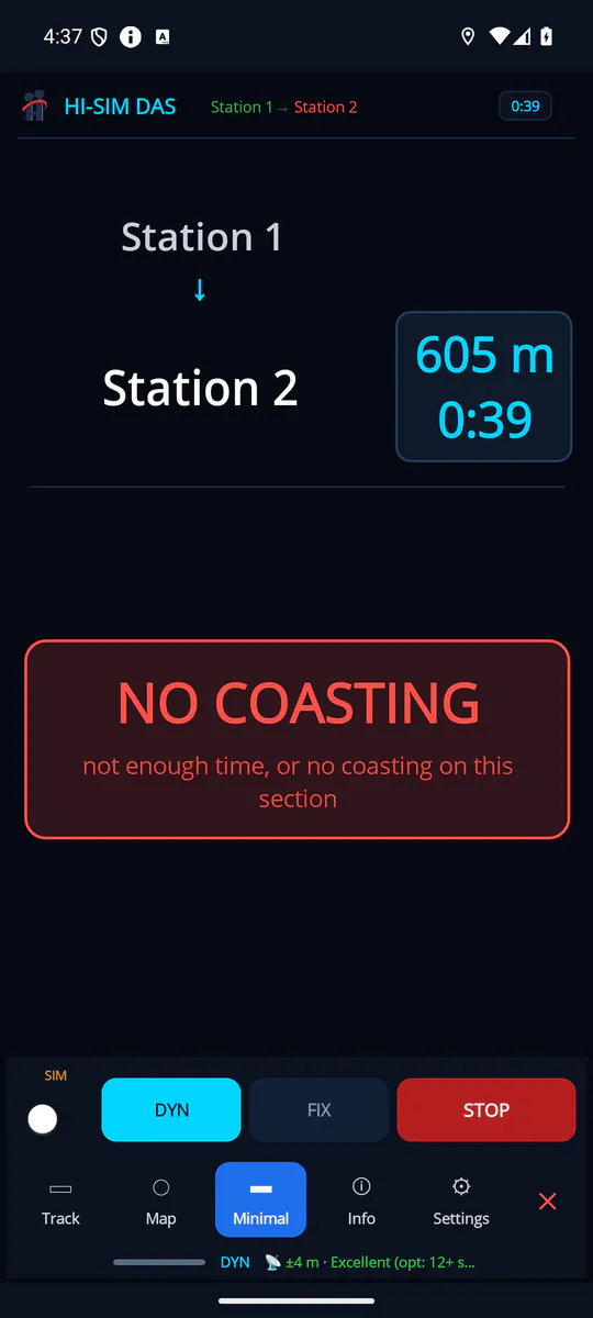
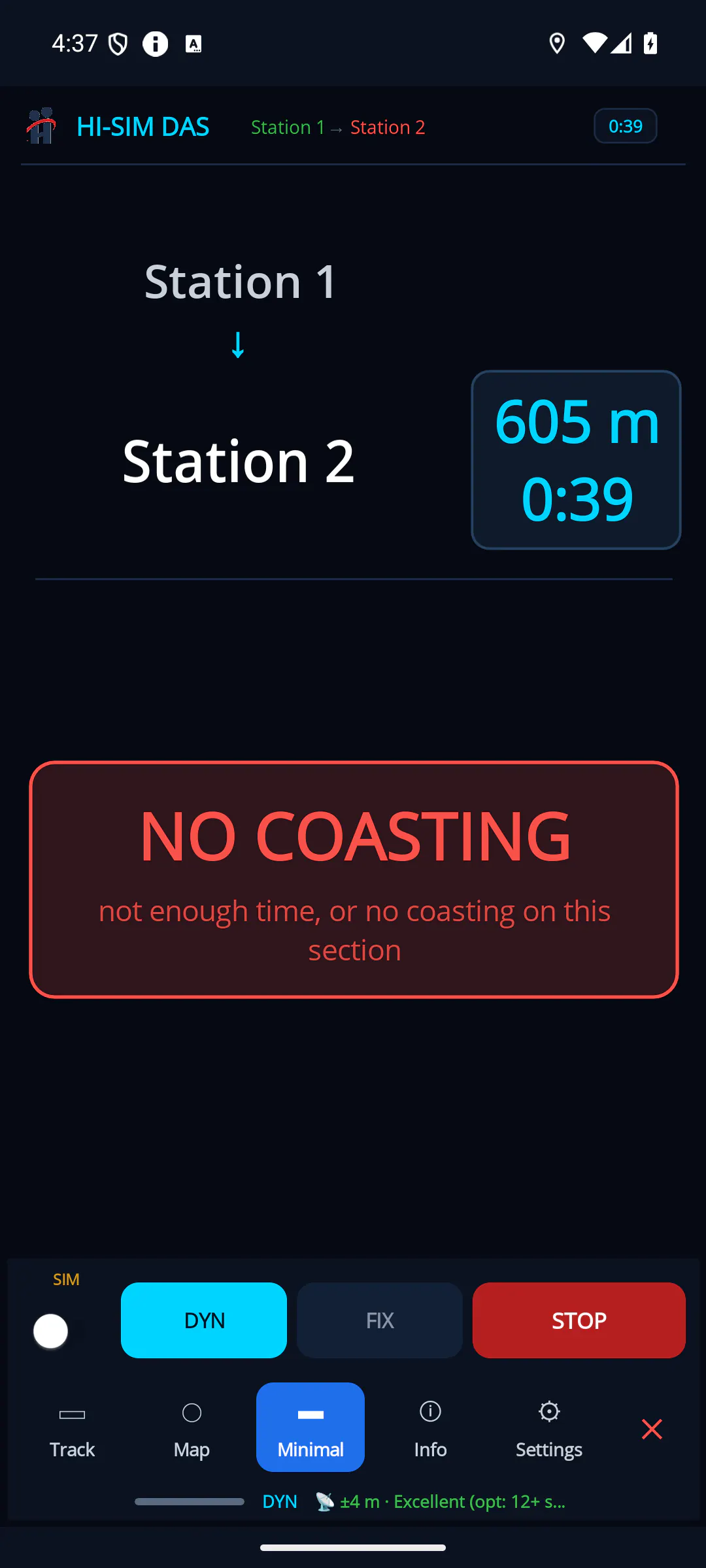
Minimal 2 next station, remaining distance and time; the NO COASTING card 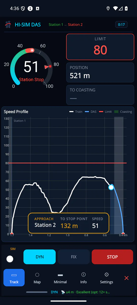
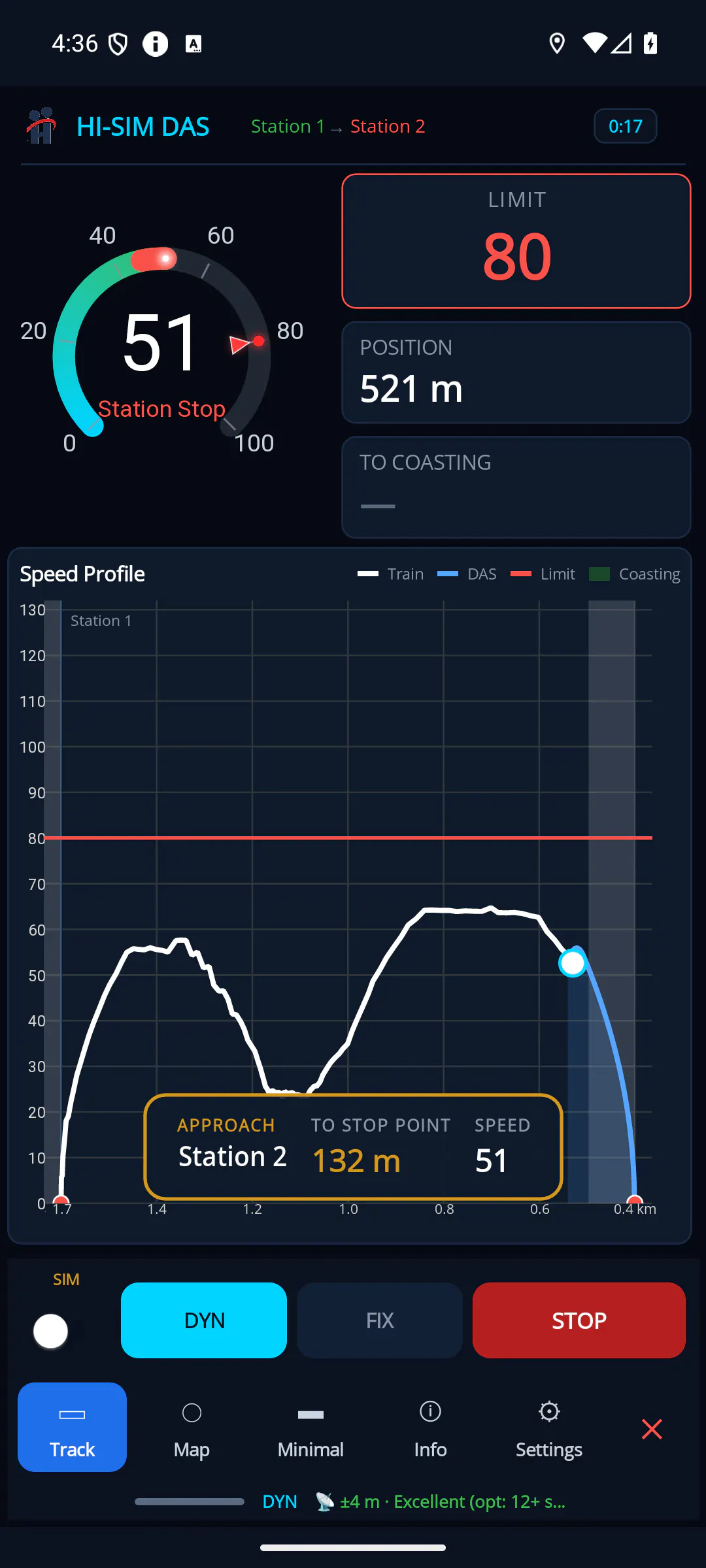
Track · STATION STOP distance and speed to the stop point 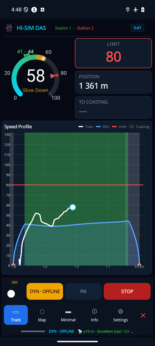
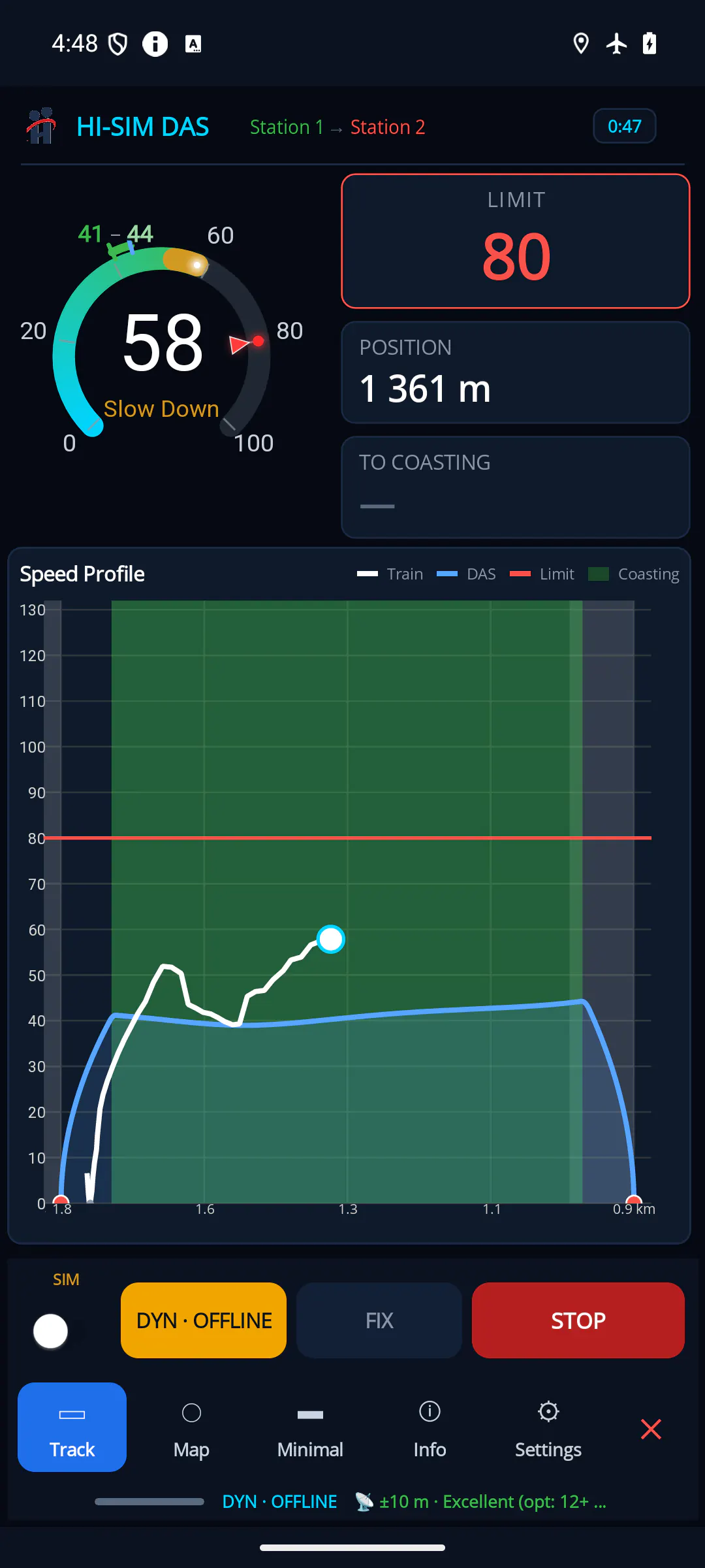
DYNAMIC · OFFLINE local profile without a connection and the SLOW DOWN advice 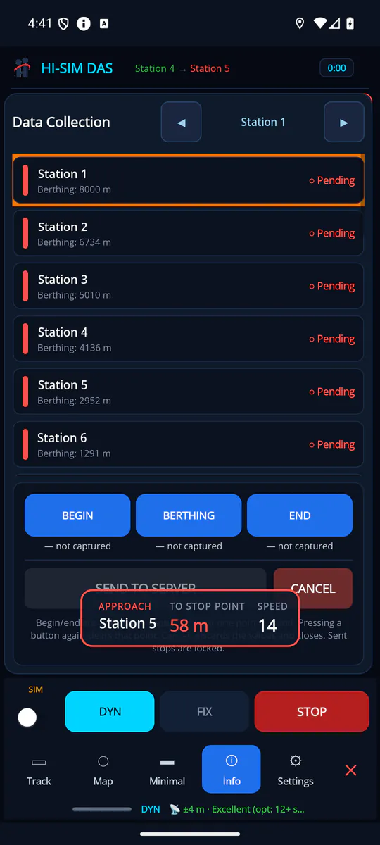
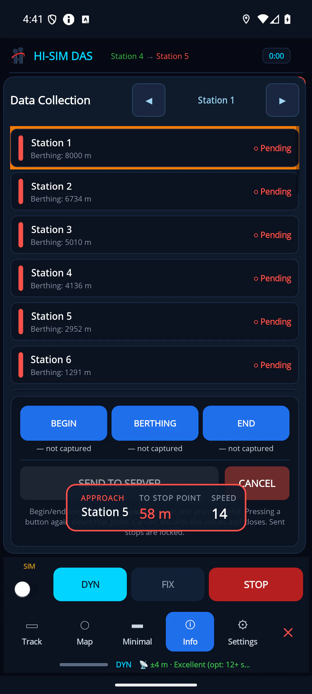
Info recording the station berthing points (Data Collection)

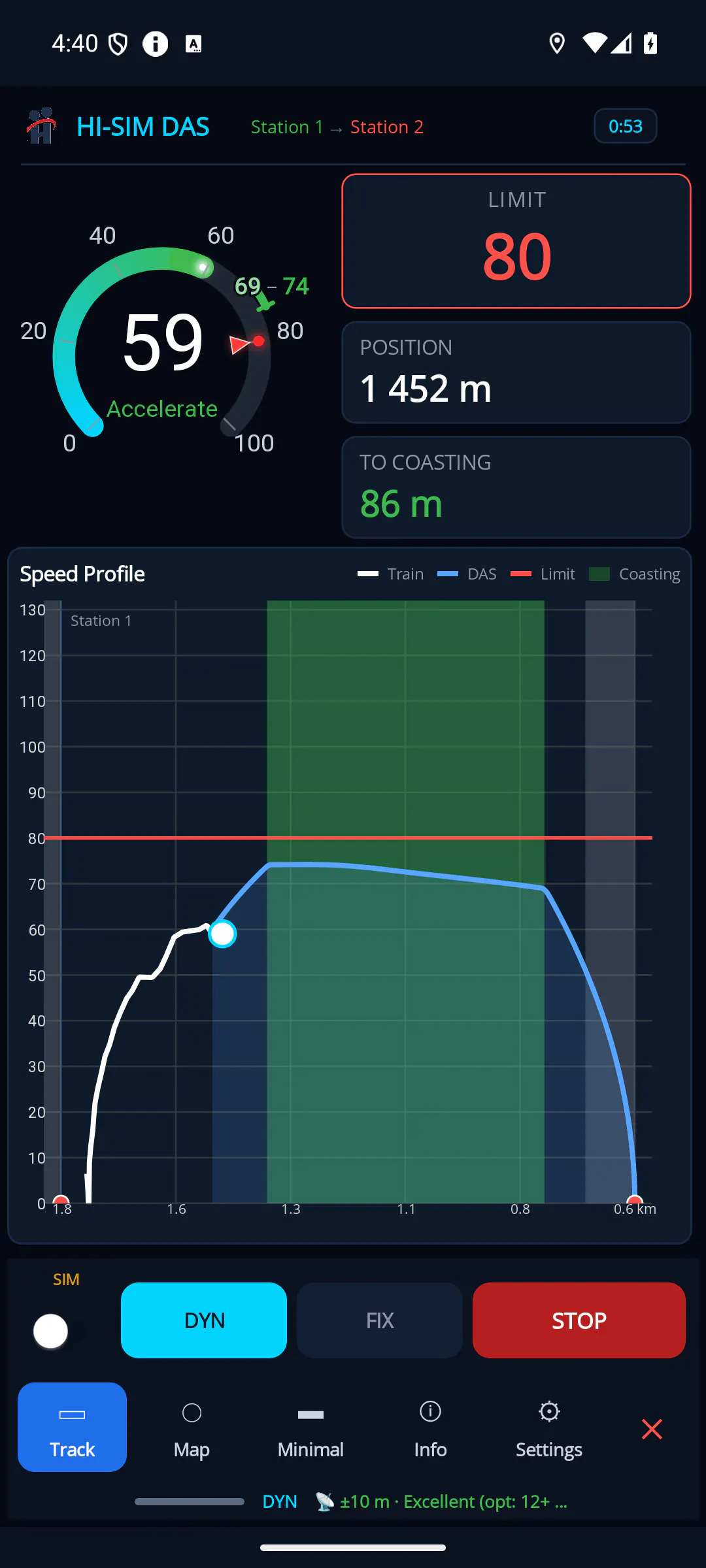
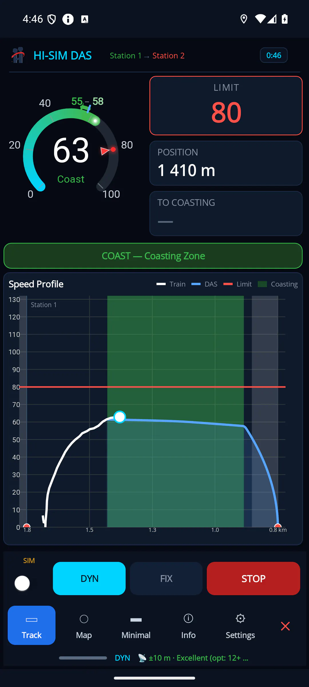
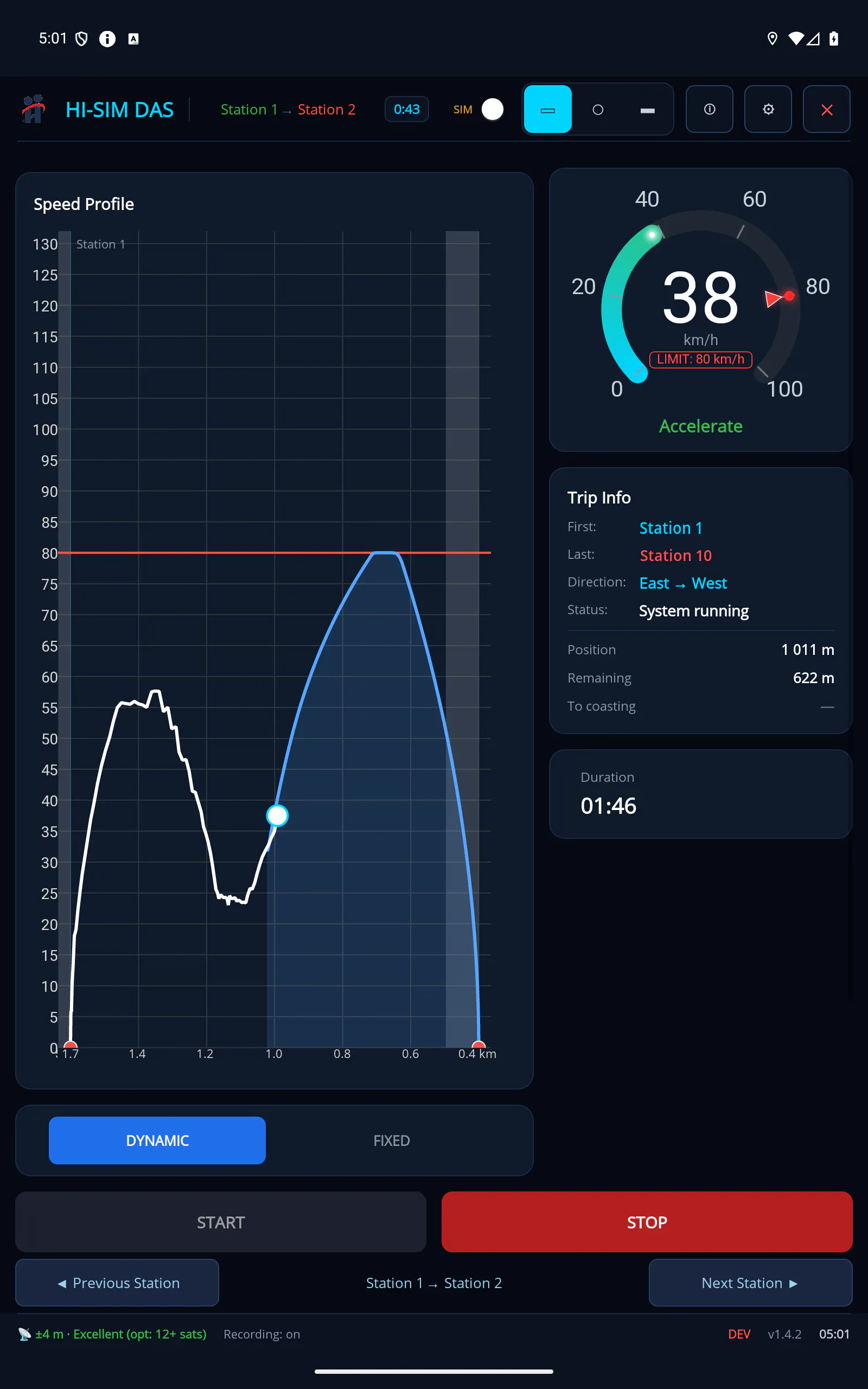
Real HISIMDAS screens in simulation mode; station names and positions are placeholders.
Driver guidance
HISIMDAS is a driver advisory app that guides the driver towards eco-driving throughout the trip. Running on a phone or tablet, it tracks the train's position and speed, shows the advised speed profile between stations and tells the driver, in short commands, what to do right now: apply traction, hold speed, coast, brake or stop at the station. The app is advisory only; it does not control the train, and the driver always makes the decision.
Advice states
- ACCELERATEApply traction
- HOLD SPEEDHold your speed
- COASTCut power, coast
- SLOW DOWNBrake to slow down
- STATION STOPStop at the platform
- HOLD STEADY SPEEDFIXEDOn the advised speed
- WITHIN MARGINFIXEDWithin tolerance
The advice the driver sees comes from the phase that the advised speed profile plans for the stretch the train is entering. Labels are given as they appear on screen (English interface, with the Turkish label in brackets).
| On-screen label | Colour | When it appears | What the driver should do |
|---|---|---|---|
| ACCELERATE (HIZLAN) | Green | The profile plans a traction (acceleration) phase on this stretch. | Apply traction up to the advised speed. |
| HOLD SPEED (SABİT HIZ) | Blue | The profile plans running at constant speed on this stretch. | Keep the speed steady. |
| COAST (SÜZÜL) | Green; amber in the phase that coasts along the speed limit | The profile plans a coasting phase on this stretch. Amber coasting is the phase in which, with traction off, the speed follows the speed limit (usually on a down gradient). | Shut off traction and let the train run freely. |
| SLOW DOWN (YAVAŞLA) | Amber; red when overspeeding | The profile plans a deceleration phase on this stretch, or the train is above the speed limit. | Brake to reduce speed. |
| STATION STOP (İSTASYON DURUŞU) | Red | The profile reaches its stop phase at the stopping point of the next station. | Bring the train to a stand at the stopping point. |
| Waiting (BEKLENİYOR) | Grey | Before the trip starts. | Start the trip. |
Overspeed always comes first: when the train exceeds the speed limit, the advice turns to a red SLOW DOWN, whatever the profile says.
In FIXED mode and while offline the main advice compares the current speed with the advised speed at that point:
| On-screen label | Colour | Meaning |
|---|---|---|
| Hold Steady Speed (SABİT HIZLA GİT) | Blue | Speed is practically on the advised speed (within a tenth of the adherence threshold, at least 0.5 km/h). |
| Within Margin (MARJİN İÇİNDE) | Green | Speed is within the adherence threshold. |
| SLOW DOWN (YAVAŞLA) | Amber | Speed is above the advised speed by more than the threshold. |
| ACCELERATE (HIZLAN) | Green | Speed is below the advised speed by more than the threshold. |
The adherence threshold is 5 km/h by default; it can instead be set as a percentage of the advised speed (default 10%). Written advice can be switched off in the settings (Driving Advice, on by default).
Coasting zone
Coasting zones are the stretches that the advised speed profile marks as a coasting phase.
- Location: Shown as a green area on the speed profile chart. The zone starts and ends at the first and last point of the coasting phase in the profile, taking the direction of travel into account.
- Distance to coasting: The To coasting card shows the distance in metres to the start of the nearest coasting zone ahead. If there is no coasting zone ahead, the value stays empty.
- Target speeds: The app shows two target speeds: coast start (the speed at which to begin coasting) and coast end (the speed at which coasting ends). Once coasting begins, the coast start speed is frozen and shown with a tick; the coast end speed stays live throughout the coast.
- Colour guidance: The active target (the start speed before coasting, the end speed while coasting) turns green when the current speed is within the threshold, amber within 15% of the target, and red (start) or blue (end) when further away. When the current speed comes within the threshold of the active target, the speed readout is highlighted as well.
- Speedometer: The speed range between coast start and coast end is drawn as a green arc on the speedometer.
- Entering the zone: In DYNAMIC mode, when the advice is COAST, the COAST: Coasting Zone banner appears; on the Minimal screen the state band adds "release throttle".
- When coasting is not possible: If there is no coasting zone ahead (the remaining time is too short for coasting, or the section has none), Minimal 1 shows "no time left for coasting" and Minimal 2 shows a red NO COASTING notice with a short reason.
Next station: distance and time
- Station name: The previous and next stations appear in the top strip; the next station also appears on the info card. Stations removed from the trip (skipped) do not count as stops.
- Distance: The distance to the stopping point of the next station, in metres below 1 km and in kilometres with one decimal above. The Position card shows the train's current chainage on the line; the Remaining card shows the distance to the stopping point.
- Time: The time to the next station is read from the advised speed profile, from the train's current point to the stopping point. The estimated arrival time is the clock time plus the remaining time (arrival HH:mm, remaining mm:ss).
- Settings: Next Stop Time (on by default), Total Trip Time (remaining time of the whole trip, off by default) and Time Rounding (none, 15, 30 or 60 s).
- Arrival detection: The train counts as arrived when it drops below 10 km/h within 80 m of the stopping point, stops within 200 m of it, or passes it slowly; a train that runs more than 200 m past the stopping point without stopping also counts as arrived. When the train departs past the stopping point, the app moves on to the next station section by itself. The status line announces the approach to the last station, and on arrival the trip is marked complete.
Audio and visual warnings
Overspeed (current speed more than 2 km/h above the line speed limit):
- The whole screen flashes red; the larger the excess, the stronger the red and the faster the flashing. This visual warning does not depend on the sound settings.
- The advice turns to a red SLOW DOWN; on the map view the train symbol turns red.
- A beep sounds and speeds up as the excess grows (from one beep per second down to one every 0.15 s).
- A spoken "speed limit exceeded" message is played together with the limit value; if the overspeed continues, it repeats at the set interval (10 s by default).
- When the speed limit changes, the new value can be announced aloud (off by default).
- Spoken messages are in Turkish in the current version.
Deviation from the advised speed (optional, off by default): when the speed deviates from the advised speed by more than the adherence threshold, a banner above the chart reads "X km/h above/below the advised speed" with an ACCELERATE or SLOW DOWN action. It is amber when too fast and blue when too slow.
Approach banner: When the train is moving and within 400 m of the next stopping point, the APPROACH banner opens with the station name, the distance TO STOP POINT and the current SPEED. It is amber and turns red in the last 120 m. It is not shown on the Minimal 2 screen or while a full-screen panel is open.
Wrong direction: If the train moves a total of 50 m against the selected trip direction, a wrong-direction warning appears in the status line. The trip is not stopped; the driver is asked to check the direction or trip selection.
Warning settings and defaults
| Setting | Default |
|---|---|
| Beep Alert | On |
| "Speed Limit Exceeded" Voice | On |
| Repeat Overspeed Voice | On |
| Repeat Interval | 10 s (0.5 to 60 s) |
| Limit Change Announcement | Off |
| Driving Advice | On |
| DAS Deviation Warning | Off (inactive when Driving Advice is off) |
| Speed Profile Adherence Threshold | 5 km/h or 10% |
These settings can be managed centrally by the operator's administrator. Managed settings appear locked on the device ("Managed by your administrator"), and the driver sees a short notice when they change. Language and screen brightness remain adjustable by the driver by default.
Screen views
In the cockpit, the Track / Map / Minimal selector offers three main views; Info is a separate tab.
- Track: The speed profile chart. Actual speed (white line), advised DAS speed (blue line), speed limit (red), coasting zones (green area), station dwell zones (grey area) and station markers are drawn together, with the train's current place marked at the tip of its trace. Samples with uncertain positioning are set apart as a grey dashed line labelled GPS Uncertain. By default the chart follows the train in a 3 km sliding window; optionally the whole trip can be drawn in one chart. Next to the chart are the speedometer (advice text, speed-limit pointer, coasting arc), the LIMIT, Position and To coasting cards, the next station and the trip information.
- Map: A live map showing the line, the stations and the train symbol at its real length, aligned with the track; the map follows the train. A card at the top shows current speed and speed limit. If the line has no position data, the speed profile chart is used instead. The map background is loaded from an online map service, so it needs a connection.
- Minimal: A pared-down screen focused on coasting, available in two layouts chosen in the settings (Minimal 2 by default):
- Minimal 1: Current speed, coast start and coast end speeds (with colour guidance), distance to coasting, next station, arrival time and remaining time, plus a large state band (ACCELERATE, HOLD SPEED, COAST, SLOW DOWN, STATION STOP). This band always shows the profile phase, whatever the mode, and turns to a red SLOW DOWN on overspeed.
- Minimal 2: Only the departure and arrival stations, the remaining distance and time next to the arrival station, and the coast start (green) and coast end (red) speeds in large type; a red NO COASTING notice when there is no coasting.
- Both layouts keep the START / STOP button on screen and work in portrait and landscape.
- Info (Data Collection): A data collection screen rather than driving guidance. While a trip is running, the start, stopping point and end positions of a station are captured from the live position and sent to the central system, where they are used to improve station position data.
Dynamic and FIXED modes
The driver chooses between two modes (unless the administrator has locked the mode); DYNAMIC is the default.
- DYNAMIC: The advised speed profile is recalculated every few seconds (every 3 s by default) from the train's current position, its speed and the remaining planned running time of the station section. Coasting points and target speeds therefore follow whether the train is ahead of or behind the timetable. The driver can adjust the time budget by double-tapping the speed profile chart: a tap near the origin station removes time, a tap near the destination adds time (5 s per tap by default). This adjustment applies only in DYNAMIC mode.
- FIXED: Uses a profile calculated with predefined, fixed coasting zones for each station section. On the first section of the trip, the profiles of all sections are downloaded and stored on the device; later sections open without a connection and are refreshed in the background at each section when a connection is available. Advice compares the current speed with the advised speed (Hold Steady Speed, Within Margin, ACCELERATE, SLOW DOWN). It is designed as a fallback plan for lines with weak coverage.
- Automatic static profile (DYNAMIC · OFFLINE): If the calculation service cannot be reached in DYNAMIC mode, the app switches to a static profile by itself; the mode chip turns amber and reads "DYNAMIC · OFFLINE". Meanwhile the advice uses the same threshold comparison as FIXED mode. When the connection returns, the app switches back by itself to a dynamic profile calculated from the train's current position. The driver does not need to do anything.
Position and speed estimation
HISIMDAS needs no extra on-board hardware; position and speed come from the phone's or tablet's own sensors.
- Satellite positioning (GNSS): Position and speed come from the device's satellite receiver. While a reliable measurement is available, the speed on screen is the measurement itself.
- Snapping to the track: The position is snapped onto a detailed geometry of the line to obtain the train's chainage. Position jumps that the train's speed cannot explain are treated as suspect; until a new position fix on the track confirms such a jump, the stopping point does not count as passed and the app does not move on to the next section.
- Motion sensors: The device's accelerometer is combined with the satellite measurements to bridge the gaps between fixes and short outages, and helps detect standstill.
- Calibration: A short calibration at trip start collects satellite data. After each trip the app refines its device-specific settings in small steps and rolls back the last change if the result gets worse.
- Behaviour during outages: In short outages such as tunnels, position and speed are bridged for about half a minute; in longer outages the position is held, the speed falls to zero and the app does not invent movement. The status strip shows the number of satellites, the accuracy and the signal quality.
Working without a connection
- Line and train lists are stored on the device, so a trip can be selected out of coverage. Only line data that has changed is downloaded again.
- Line geometry ships with the app or is downloaded and stored with the line data; snapping the position to the track needs no connection during the trip.
- Advised speed profiles are stored on the device and stay valid until the underlying line, train or calculation data changes. At the start of a DYNAMIC trip, while connected, the static profiles of all other sections are downloaded in advance; in FIXED mode all sections are downloaded at the start of the trip.
- When the connection drops, DYNAMIC mode falls back in turn to the stored static profile, to the matching slice of the whole-trip profile, or to a simple fallback profile, and switches back automatically as described above.
- Settings: The last valid settings are stored on the device and used unchanged without a connection.
- Trip records: If the records cannot be sent at the end of the trip, they are kept on the device and resent automatically at the next sign-in, at app start or after the next successful upload. Trip data is saved to the device at regular intervals during the trip, so it survives an unexpected app shutdown.
- Limits: The first sign-in needs a connection; the map background needs a connection.
Compliance feedback
During the trip the driver sees how closely they follow the advised profile:
- In FIXED mode and while offline, the Hold Steady Speed / Within Margin / ACCELERATE / SLOW DOWN advice states the adherence directly.
- The coast start and coast end target speeds are coloured green, amber and red/blue against the adherence threshold, and the speed readout is highlighted when the target is reached.
- The optional deviation warning states the size and direction of the deviation.
- The speed chart shows the actual speed line over the advised speed line.
End-of-trip summary
When the driver ends the trip with STOP, the TRIP SUMMARY screen opens:
- DURATION and DISTANCE: The trip time and the distance covered after the first satellite fix.
- COASTING: The number of missed coasting opportunities (traction applied inside a coasting zone) and the distance run in traction there.
- SMOOTHNESS: The number of harsh brakes and harsh starts (passenger comfort threshold 1.4 m/s²).
- OVERSPEED: Total time above the speed limit and the highest excess.
- ADHERENCE SCORE: The share of time spent within the adherence band around the advised speed; 85% and above is GOOD, 65% and above is FAIR, below that POOR. This is the driver's immediate summary on the device; the driving score in the Hi-SimTrain reports is calculated separately once the trip is uploaded, from speed adherence, coasting compliance, on-time arrival and smoothness.
- ADHERENCE BAND DISTRIBUTION: The percentage of time in band, above the band and below the band.
- Events: Overspeed, missed coasting, harsh braking and harsh start events, each with its position on the line.
The summary can be shared as text and, once closed, reopened from the settings. For very short trips where not enough measurements were collected, a short note is shown instead.
Safety principles
- Position and speed come from the device’s GNSS receiver and motion sensors, matched to the track geometry; no extra on-board hardware is needed.
- It does not connect to signalling or ATP and never acts on the train; it only gives advice.
- Coasting is advised only in defined zones; safety and timetable limits always come first.
FAQ
Does HISIMDAS need extra hardware?
No. An Android 8.0+ phone or tablet is enough; position and speed are estimated from the device’s GNSS receiver and motion sensors. No signalling or ATP connection is used.
What happens if the connection drops?
The app automatically falls back to the static profile computed at the start of the trip and keeps giving advice; the screen shows this state.
Who can use the app?
HISIMDAS is for organisational use by railway operators, not for personal use. Drivers sign in with accounts set up by the operator.